It was around the middle of October – the perfect time to be in the mountains. The monsoons had recently receded, and the sun shone bright and warm. The mountains slopes, still drenched, looked fresh and invigorated, and the clouds had now finally surrendered after putting their all for the past 2 months.
I thoroughly enjoy the month of October, and to an extent November too. Not that I detest any of the other months, but as a mountain lover who loves to wander deep into the hills, this time of the year is ideal. I am less worried about the risk of incessant rains or road blockages that could completely jeopardize the trip. Most of all, this season provides me a greater chance of capturing clear views of the serene, snow-clad peaks. After all the sweat it takes to trudge up to the summit, you want to be rewarded with those pristine, unobstructed vistas.
For some time, I had been planning a trek to Har ki Dun, a mesmerizing high-altitude valley, nestled in the western Garhwal region of Uttarkashi, bordering Himachal Pradesh. This area, also known locally as the Rewai valley, is home to semi-nomadic communities with a rich cultural heritage and deep-rooted traditions.
Uncovering the trek to Har Ki Dun, the valley of Gods
A spotless blue sky stretched above as we set off from Dehradun, driving through Mussoorie, then onward to Nainbag, Naugaon, Purola, and Mori. From Mori, we veered off the main road, following a detour that traced the path of the Tons River. By the time we passed Mori, night had fallen, and we could hear the faint hymn of the Tons’ rushing waters. As we travelled, the road grew bumpier, but our excitement about reaching Sankri and starting the trek kept our spirits high. We passed through the town of Netwar, where the Rupin and Supin rivers merge to form the Tons, and then continued the winding ascent to Sankri. At last, we arrived at Saur village, about a kilometre beyond Sankri, where we had booked a hotel and planned to meet our guide for a briefing on the trek.
Sankri has become a name to reckon with in the world of hiking. With numerous treks in the area, this place is highly sought after. In particular, the Kedarkantha trek—a popular all-season trek, especially during winters—attracts people from across the country.
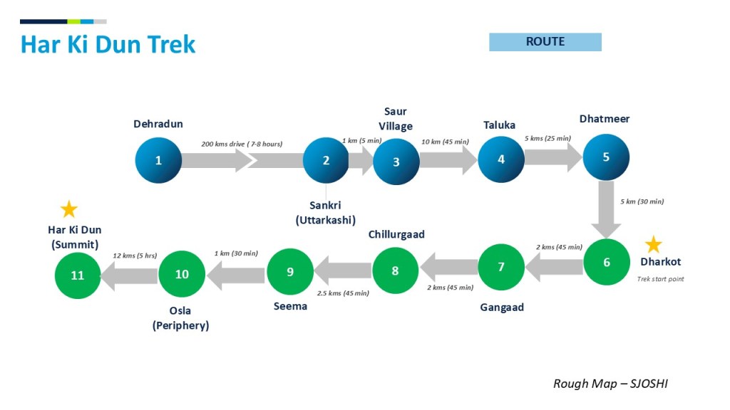
For the Har Ki Dun trek, Sankri or Saur serves as the starting point for this exhilarating journey, covering over 40 kilometers round-trip. Let’s walk through it together.
Day1: Saur to Chillurgaad

After a quick dinner and briefing from our guide, we slipped into a deep sleep. The next morning, after breakfast, we began our journey. Our trek company arranged a jeep, as the rough road beyond Saur is best navigated by a sturdy vehicle like a Bolero. Road work is underway, aiming to connect the last remaining villages in this area (Borasu Patti). Borasu Patti is a territorial unit that consists of 4 villages along the Supin river. These include 1) Dhatmeer 2) Gangaad 3) Pauni Gharaat and 4) Osla. All these villages have maintained a rich local culture and revere a local deity called Lord Someshwar (considered an avatar of Lord Shiva).
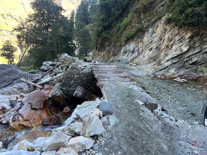
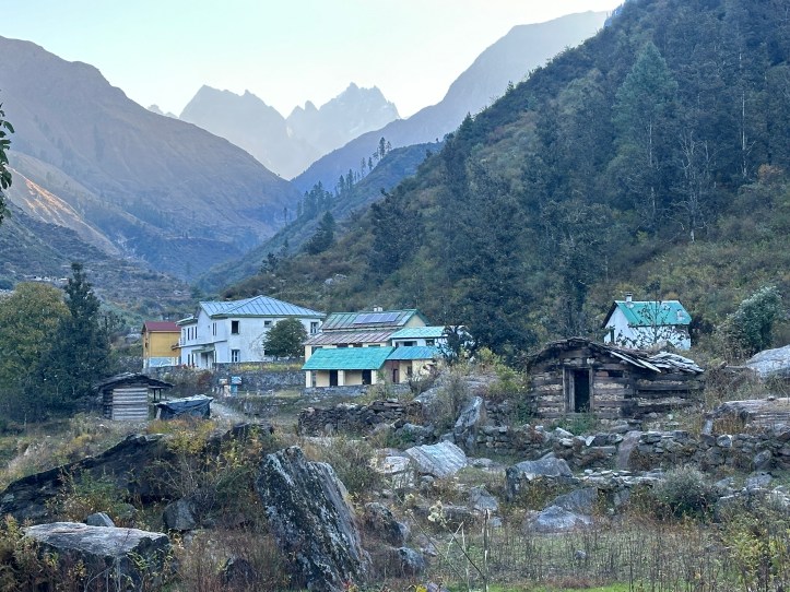
As we continued the drive, the scenic vistas unfolded before us, with the morning glow of the rising sun gently bracing the tops of thick forests of oak, deodar and palm. In the distance, we could see clusters of houses, all decked up beautifully in wood. It was a wonderful sight. Soon, we arrived at Taluka village, which used to be the starting point of the trek until recently, however, the road now extends even further. The drive continued until Dhatmeer, where a landslide forced us to get down and start our journey on foot. Had the landslide not been there, we could have driven another 5 kms. No regrets.
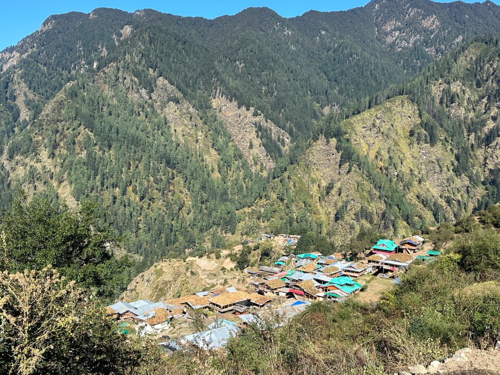
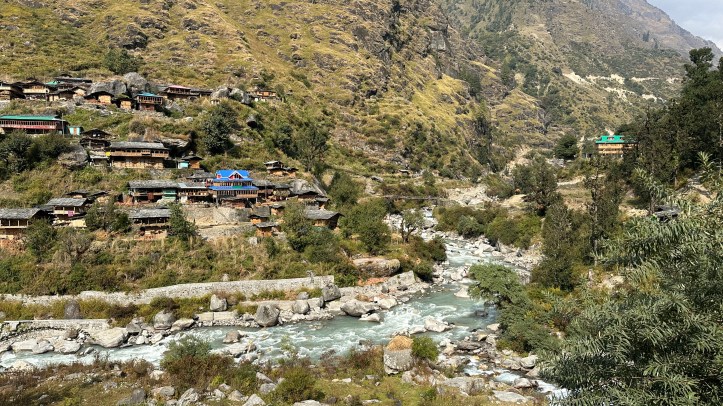
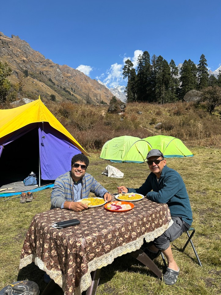
We started our trek from Dhatmeer, walking on the under-construction road until Dharkot (an extension of Gangaad village), so this section was near flat. At Dharkot, we stopped for a cup of hot, steaming tea before taking a downward trail to Gangaad village. Nestled along the Supin river, the houses appeared stunning, perched on the slopes. It is a large village by hill standards, and I was told that roughly 110+ families reside here. We took a brief stop to enjoy our packed lunch, then began our final push for the Chillurgaad campsite. The ascent was comfortable, with Supin river flowing alongside the trail, and the towering cliffs protecting us on both sides.
Day2: Chillurgaad to Har Ki Dun
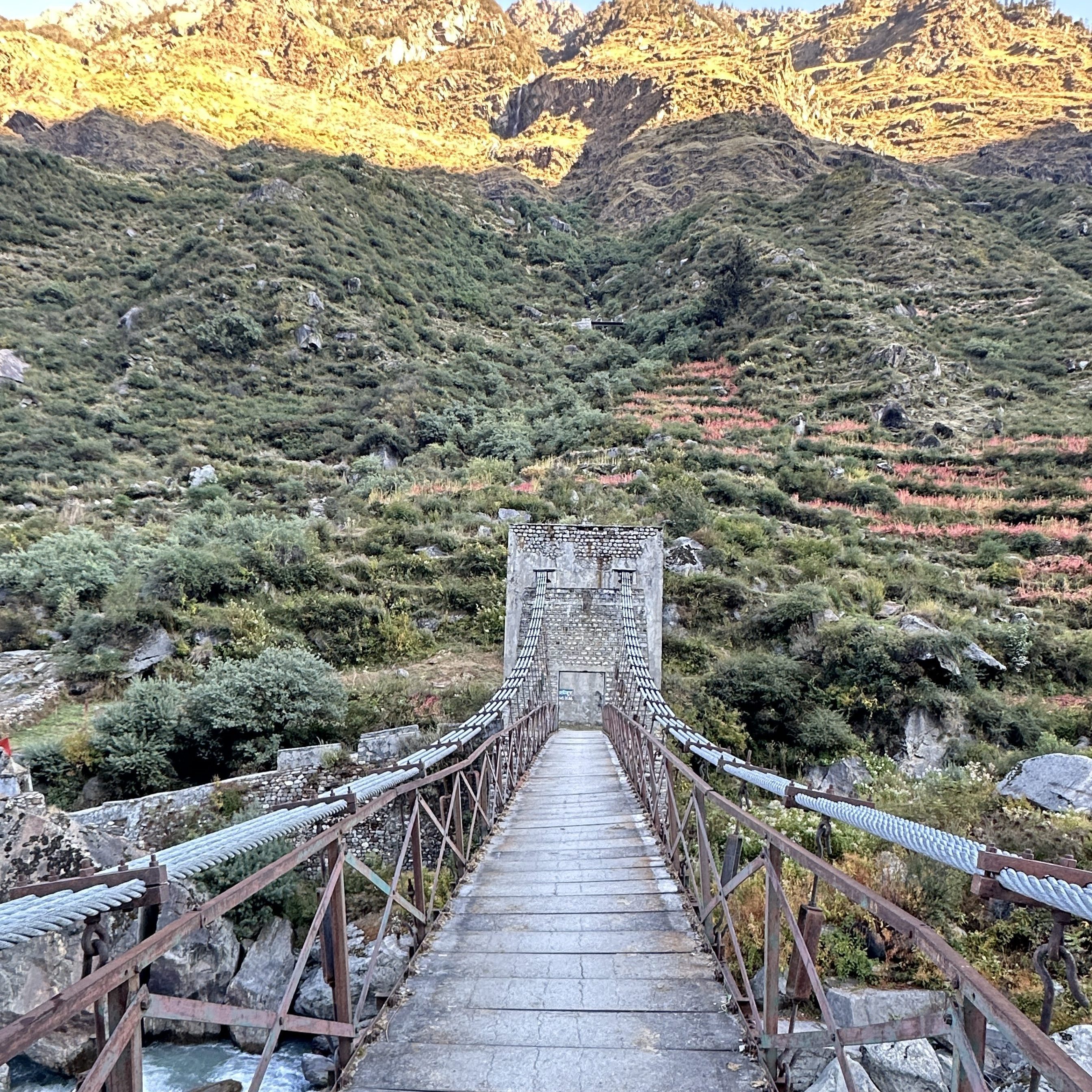
We started before daybreak, as it was going to be a long day of walking – roughly 18 kms. We continued along the Supin river until we reached Seema, our first rest point. Beyond this, we crossed over to the other side of the river,where paths for several interesting treks diverge. These include the routes to Ruinsara lake, Black peak base, Swargarohini base, and the famous high-altitude Bali Pass trek that leads to Yamunotri.
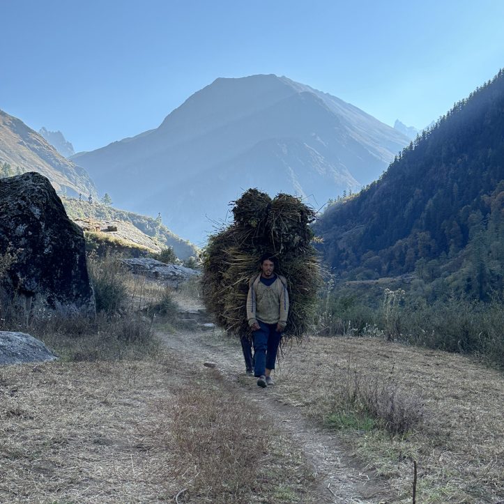
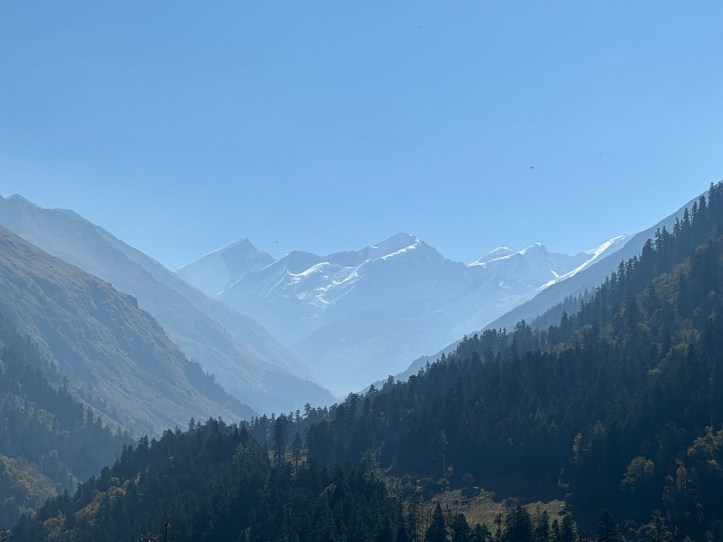
Along the way to Har ki Dun, we met some villagers from Osla who were collecting grass from the fields to take back to their village. The path had a steep gradient all the way to a ridge locally known as Kalkatiyadhar. As we gained altitude, the views became more spectacular. Black Peak (Kalanag) and the Bandarpoonch ranges unleashed themselves as the morning sun illuminated their gentle white surfaces.
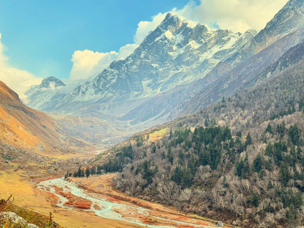
By early afternoon, we arrived at our campsite, en route to the Har ki Dun summit. We had our lunch, left our heavy bagpacks in the tents, and continued onwards with a light bag to our final destination, the Har ki Dun summit. The ascent was steep, the tree line receded, and the towering rocky peaks with snowcaps seemed closer and closer.
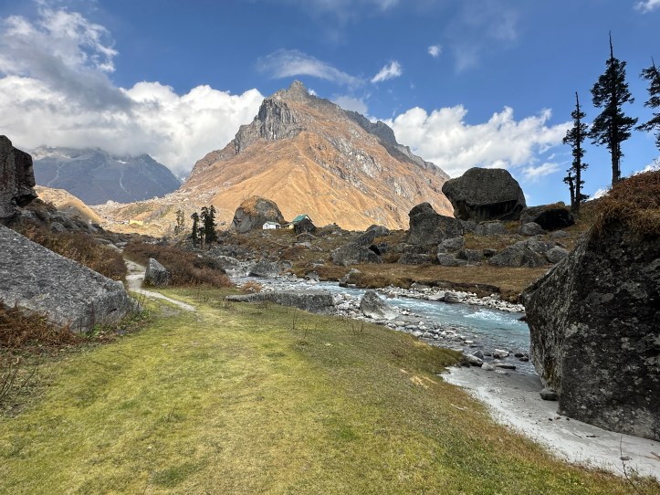
No words can truly capture what we saw at the summit. The towering Himalayas, the lush grasslands, the meandering river, the glacier laden with snow, and slopes covered with birch and spruce trees, all of it so close as if we could reach out and feel them.

The late afternoon air was heavy and cold, with a chill breeze flowing as clouds began to gather. We soaked in the atmosphere, capturing the moments with our cameras, marvelling at nature and all the mountains had to offer. The Har ki Dun summit stands at roughly 3,500 metres above sea level. From here, the Swargarohini peaks look stunning, almost as if they are watching you from up close. In the distance, Jaundhar glacier, the source of the Supin river, is also distinctly visible. From here, via the Borasu pass, one can cross over into the Sangla valley in the Kinnaur district Himachal Pradesh.
When you put in all the effort to climb up the mountains, nature rewards you in the end. We couldn’t have asked for a better reward.
Day3: Har Ki Dun (Campsite) to Sankri (via Osla Village)
It was time to head back to our base at Sankri, with another long walk ahead. Fortunately, most of the trail was downhill, so we weren’t too concerned as long as we could reach Sankri before the sun dipped low on the horizon in the evening.
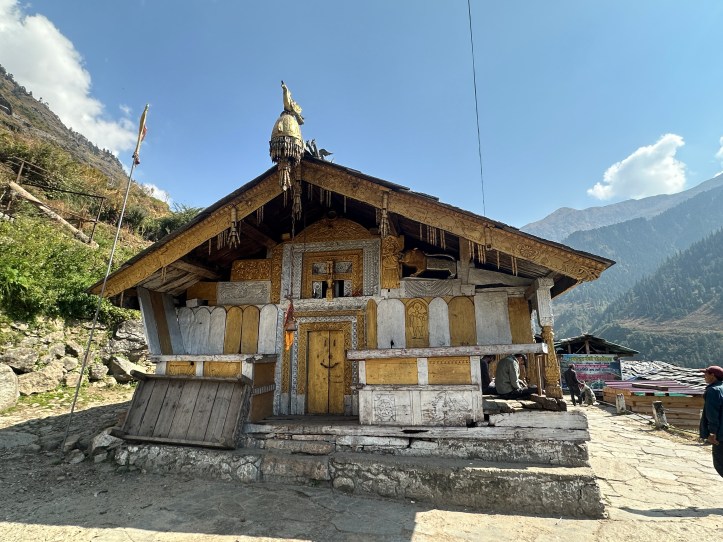
On the way back, instead of retracing our path through Seema, we took a small detour to Osla village. I had heard much about Osla and its unique customs, and I wanted to experience it firsthand. Nestled at 2,600 meters above sea level and the closest village to Har Ki Dun, Osla is home to roughly 150 families who live in intricately crafted wooden houses. At the heart of the village stands the beautifully adorned Lord Someshwar temple, with rich carvings and impressive craftsmanship. Friendly villagers greeted us warmly, and I enjoyed brief conversations to learn more about life in the village.

Soon, we began our descent, heading down to Chillurgaad, and then following the same path we had taken on Day1 (albeit in reverse). By late afternoon, we arrived at Dharkot, where we learned that the landslide section near Dhatmeer had been cleared, and that taxis were now reaching Dharkot. We waited for the next taxi, which quickly took off once it was filled with the required number of passengers, including a few adventurous souls who took seats on top of the vehicle.
Darkness began to knife away the last traces of daylight as the sky turned a soft purple, stars slowly started to flicker, and the distant mountains formed gentle silhouettes in the crisp October air. We were finally dropped off at Saur village, and an unforgettable trek had come to a close. I hope you enjoyed it too.
Planning a Trek to Har Ki Dun: Helpful Pointers
| Location of Saur Village | https://maps.app.goo.gl/JURR2VgbdDsNCYYv5 |
| Accommodation Options | We stayed at Hotel Grand Shiva. Decent accommodation. There are several other hotels around. |
| Trek Guide Reference | Prahlad (Contact: 9410366415) was our trek guide. We thoroughly enjoyed his company and appreciated his deep knowledge and professional approach. Highly recommended! |
| Trek Distance and Duration | Approximately 40-45 km, depending on road conditions beyond Dhatmeer. The trek (Sankri to Sankri) can take between 3 to 5 days, based on your pace. |
| Best time to travel | April-May, and then mid-September to mid-November. |
| Traveling to Saur or Sankri from Dehradun | There are several buses between Dehradun and Sankri. If you book through a trek operator, they’ll usually handle transportation. Road conditions are good up to Mori, but beyond that, it’s mostly rough. |
| Is It Worth the Hike? | Absolutely! You won’t regret it 😊 |

A masterpiece!!!
Congrats on your first Video clip.. Nice upgrade 👌
LikeLiked by 1 person