
Dodital is the source of the Assi Ganga river, one of the tributaries of the holy Bhagirathi River. The entire Assi Ganga Valley is pristine, with rich, green mountains spiralling above endlessly cutting through the blue sky, and through which canters down the roaring waters of Assi Ganga in an unstoppable rush. Assi Ganga river, eventually at Gangori, a bustling town located right on the Uttarkashi – Gangotri Highway and roughly about 8 kms ahead of the district headquarters of Uttarkashi, merges effortlessly into the mightier Bhagirathi River. As we scramble up on the rugged Sangamchatti road from Gangori, the vistas that start to unleash before us transcend the mundane. Through most of the road journey, extending until the last road-head at Agoda village, the river shall remain your steadfast companion. It will gracefully shift positions, at times flowing on your left and then swiftly transitioning to your right, its gurgling sound mixing well with the deep rumbling of our vehicle’s engine.
Note – Until 2012, Sangamchatti used to be the start-point for the Dodital Trek. Unfortunately, in Aug’2012, there was a massive cloudburst followed by incessant rains that not only swept away the bustling marketplace here, but also washed away the bridges, a Govt. run school and even a Tourist Rest House. Sangamchatti, forever scarred by this catastrophe, bears the weight of desolation as you traverse through it. The remnants of its once-thriving structures stand as solemn witness, casting a cloud of melancholy over the surroundings. After navigating through a few bends and gaining a few hundred metres in altitude, our driver pointed towards a school which he said was built after the catastrophe. It surely stood as a resilient symbol of hope and renewal.
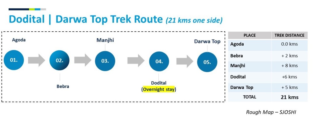
Before I delve deeper into our Dodital trek, here’s a summary of our entire journey.
| S.No. | Day | From – To | Mode of transport | Distance / Time |
| 1 | 1st | Dehradun – Uttarkashi | Own Vehicle | 150 kms / 5 hrs |
| 2 | 1st | Uttarkashi – Agoda Village | Taxi (Bolero) | 30 kms / 1.5 hrs |
| 3 | 1st | Agoda – Dodital | Trek (Easy Grade) | 16 kms / 7 hrs |
| 4 | 2nd | Dodital – Darwa Top | Trek (Medium Grade) | 5 kms / 2 hrs |
| 5 | 2nd | Darwa Top – Agoda | Walk (Easy Grade) | 21 kms / 8.5 hrs |
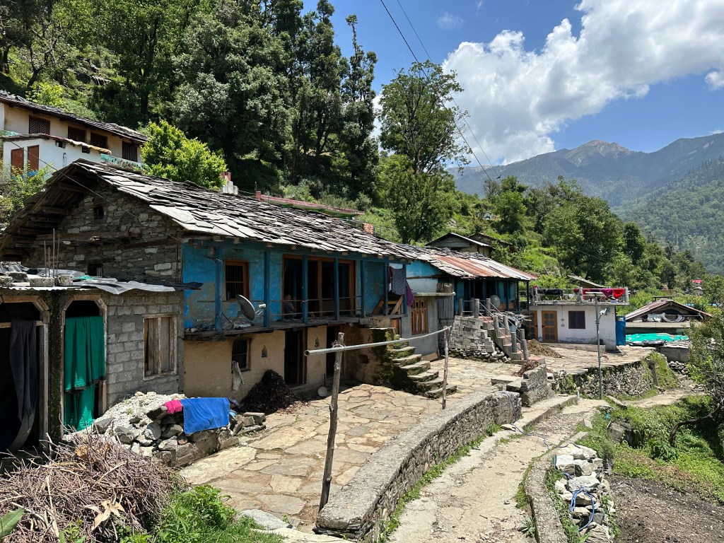
The trek began at Agoda Village, comprising approximately 100 houses. The residents of this village have been actively involved in the trekking and climbing domains for a long time.
Agoda to Bebra stretch (2kms | 45 mins walk)
This stretch is of an easy grade, with the initial trail passing through the heart of the village. Adding to the picturesque surroundings is a stunning waterfall situated on the opposite hill. We traverse a stream and reach Bebra, where vibrant farming activities are abundant, primarily owned by residents from Agoda. We stopped by a tiny rustic shack to have a cup of hot milk tea. The immediate segment beyond Bebra presents a moderate ascent and to my mind is the sole challenging section we encountered all the way until Dodital.

Bebra to Manjhi (8 kms | 4 hours walk)
The trail leading to Manjhi from here meanders through a thick, wooded area with the floor strewn with pine-needles. It is important to fill up your water bottle at Bebra since, for the next 6 kms, there are no visible sources of water available. As you ascend, the Assi Ganga river appears distant beneath you and the Agoda village also looks miniscule from this elevated vantage point. The late summer afternoon air grows noticeably cooler at this high altitude. The rustling of leaves, the crunching of gravel under the weight of our heavy boots, the sound of our laboured breathing and the continuous chatter of the Himalayan birds, got together to break the monotony of the deep silence of the forest. We carried on.
6 kms into our walk, we encountered a water source, and we quickly refilled our bottles. We were surprised to see a quaint tea shack nestled just a few metres ahead. We stopped by for a cup of tea, regained our energy and got ourselves back on the trail to Manjhi.
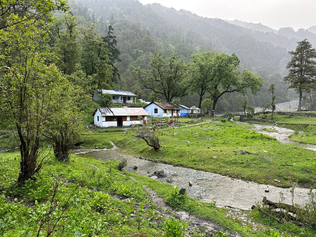
We soon arrived at Manjhi. A cluster of traditional hill dwellings with thatched roofs and wooden structures perched on a tiny meadow with numerous cows, and goats scrambling around is how I would describe this place. As the sun started the daily evening ritual to go low on the horizon, we had to pace up our walk to Dodital.
Manjhi to Dodital (6 kms | 2 hrs walk)

We couldn’t have asked for a better trail than this. The ascent was gradual as we ventured through dense forests. Along the way we encountered 2 streams that had to be carefully navigated to avoid any mishaps that could result in wet shoes and pants. A kilometre before Dodital, we arrived at Bhairon Mandir. The path from here was a gradual descent. It was now getting dark, and we hurried our pace. At about 8 PM, we arrived at Dodital.

Dodital – as the name suggests, is a high-altitude lake and is the source of the river Assi Ganga. There’s a Ganesha temple situated at the corner of the lake. It is considered that God Ganesha was born at this place. The lake looked stunning, in crystal green color, under the influence of the early morning light.
Dodital to Darwa Top (5 kms | 2 hours walk)

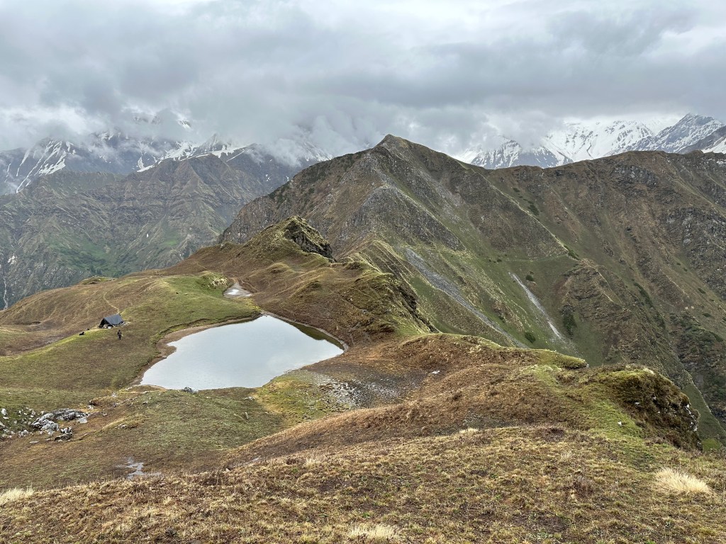
This is a tough climb as it leads to the top of the hill situated at roughly 3,800 metres altitude. From this vantage point, one has the option to descend towards the Yamuna Valley and continue all the way to Yamunotri, if desired. In the ancient times, this trail served as a passage connecting the holy places of Yamunotri and Gangotri. The path to Darwa Top is not clearly defined, and one has to frequently cross through water streams. The last 1 km presents a notably steep section navigating through large boulders. However, the soothing melody of the Himalayan Monal, emanating from a hidden spot nearby, alleviated our worries and gave us an invincible strength to reach the summit.
Hope you enjoyed reading the post.
A few pieces of information that may be helpful to you.
- Stay options are available at Dodital. For Rs 1000/- per person you get a bed to sleep on, dinner and breakfast. There are modest stay options at Manjhi and Bebra too.
- Mobile Network – Only Jio and Idea would work at Agoda and at a few places beyond Bebra.
- Highly recommended to take a guide on this trail. Also, unless you have an all-terrain vehicle, it is best to take a Bolero/jeep from Uttarkashi to Agoda. The road condition is not great, and the rains can make the matters worse. I am putting down 2 names below. They both are locals from Agoda village and are experts in their respective vocations.
- Taxi (Mr. Mahendra Panwar – 7579123085) , Trek Guide (Mr. Vishal Panwar – 7300712466)

Wow. What a description. I could almost feel as if I was taking the trek. The view of Dodital from Darwa top looked like tea in a saucer, simply beautiful. Look forward to taking the trek soon.
LikeLiked by 1 person
Indeed. Tea in a saucer is a great way to describe the view at Darwa. Highly recommended trek for the stunning views it offers. Thank you for your kind words.
LikeLike
A wonderdul read!
LikeLiked by 1 person
Amazing read, I could feel the trek and landscape contemporaneously.
LikeLiked by 1 person
Thank you. I am glad you enjoyed reading it.
LikeLike
Exploring the unexplored. Amazing read. Great insight.
LikeLiked by 1 person