While the landour and lal tibba areas are famous in their own ways with numerous cafes / restaurants serving visitors who flock here throughout the year, I was inquisitive to exploring some trek routes in and around this area.


After a lot of searching on the web, I found a couple of posts which mentioned a village called Kolti that lies somewhere at the base of the lal tibba peak. I figured out that you have 2-3 routes from/around lal tibba that can be used to trek down to this village. I chose the one that goes just around that spot at lal tibba where you have the giant telescope on a rooftop. A small muddy track is visible just next to that building (it is actually a restaurant).
Before I detail out the experience, let me summarize some of the key things ;
| Trek route followed | Char Dukaan – Lal Tibba – Legud Village – Kolti Village – Jabarkhet – Sister’s Bazaar – Char Dukaan |
| Total distance trekked | 14 kms |
| Time | 6 hours |
| Trek Grade | Easy to Moderate |
| Trek Highlights | Thick forests, waterfalls, rivers, village life, solitude |
Stretch1:- Char Dukaan to Lal Tibba (800 metres , 15 minutes)


This is a standard stretch and is popular among the tourists. The walk is an easy one with no incline at all. The cool morning breeze and the vast expanse with huge mountains all around makes the whole experience truly worthwhile. Once you arrive at the Lal tibba, take the path that goes adjacent to restaurant on the left side of the road (this is the restaurant with a giant telescope mounted on its terrace).
Note – There is not a single shop beyond this point (either on the way or in Legud or Kolti). So, in case you need to stock-up some eatables, water bottle, etc, I highly suggest that you do it right here. Carrying a small stick with you may also be helpful as you may come across monkeys in the initial stretch (you do not have to worry at all).
Stretch2:- Lal Tibba to Legud Village ( 3.5 Kms , 2 hours)
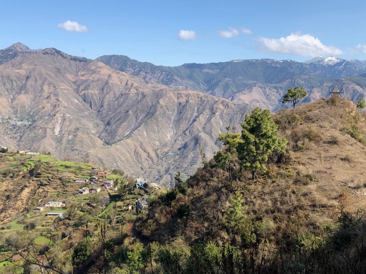
As soon as you commence your descent on the path (just around the telescope restaurant), you will start getting a different feel altogether. Away from all the crowds, into the forests, the journey will be more and more exciting. The entire stretch of this trail is downhill. On your downward journey you will meet many villagers coming from the other side. The trail passes through some thick forests (but there isn’t anything to worry about) with lots and lots of pine and rhododendron


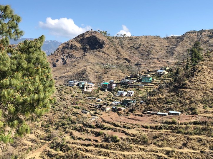
trees dotting your trail throughout. About a kilometre before the 1st destination, you will get your first glimpse of the Legud Village. A lush green village perched in the middle of these mountains makes this 1st glimpse truly amazing. The vast landscape with huge mountains including the mighty Himalayas trying to sneak out from the back, is truly breath-taking. This place and the view from here are a photographer’s delight.
The village is a quaint little town and there isn’t much to do here. I took some pictures and commenced my onward journey to Kolti village. There are 2 routes going towards Kolti from here, one is a bigger one or the main route and the other is a shorter one used by the villagers here. The main path goes round the village and eventually meets the shorter route a few hundred metres ahead.


Stretch3:- Legud Village to Kolti Village ( 2.5 Kms , 1.5 hours)
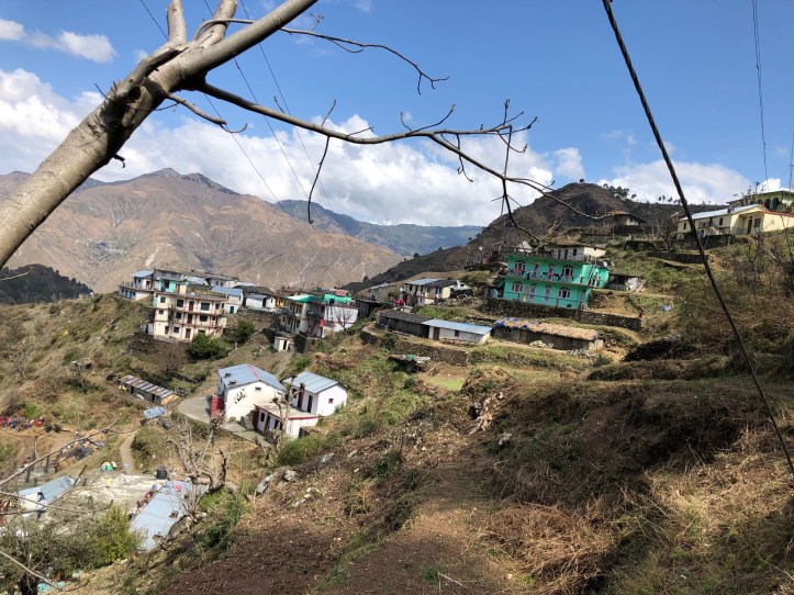
This was the most interesting stretch on this entire trail, and it had almost everything you would expect from a good and rewarding trek – i.e. great surroundings, rivers, waterfalls, typical Pahari houses along, locals busy with their regular work, etc. A truly idyllic countryside life was visible here. While the track pretty much existed, I always made sure to re-confirm whenever I saw some villagers passing-by. The route from Legud towards Kolti 1st goes downhill to the base (until you reach a river body and cross over to the other side using a small foot bridge) and then again commences as a winding trail (not strenuous at all) until Kolti.


Kolti is a small village with about 300 inhabitants and roughly 43 houses (as per the census 2011 data). The village is beautiful with nice happy faces greeting you once you arrive there. The Lal Tibba peak and its gigantic TV tower is clearly visible from here. Unfortunately, there aren’t any shops/tea-joints in the village.
There are 2 trails from Kolti ;
Trail1 – Kolti to Lal Tibba – this passes through the 3 pump houses and eventually hit somewhere near Lal Tibba. The pump houses are an old structure which lifts the water from the river below for consumption in Landour and Mussoorie areas. I have come across blogs where people have done this trail. The trek distance is only 3 kms however the route is quite steep and passes through a dense forest.
Trail2 – Kolti to Jabarkhet – This trail is not very steep compared to the previous one, however distance-wise this is about 5 kms long. Should you wish to go to Lal tibba, there’s a short-cut from Jabarkhet. Scroll-down the blog to know more….
Stretch 4:- Kolti Village to Jabarkhet ( 5 kms, 2 hours)
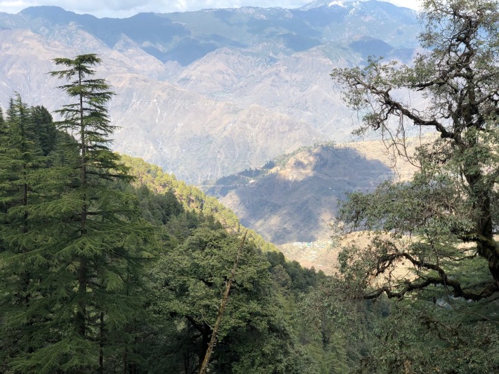
After crossing the quaint little village, in no time you will find yourself in the middle of the dense forests. At this time of the year (March-April), the red flowers from the rhododendron trees makes the jungle/ the ambience very colourful. The flowers are strewn all over the route giving you a true maharaja style feeling.


I did not find a single human soul for almost an hour+ into the trek and throughout the journey all I stumbled upon was 1 gentleman, that’s all. I was later told that for any purchase/business, the people of Kolti use the pump house trail to reach lal tibba and onwards to Mussoorie. Throughout the trek , the tall TV tower at Lal Tibba will be visible to you.
Jabarkhet lies on the Mussoorie-Dhanaulti main highway and is also home to the Jabarkhet nature reserve, quite famous among the wildlife enthusiasts. You can find a few restaurants/shops and hotels here, right on the highway. Jabarkhet is also famous due to its proximity to the famous Woodstock school. I decided to take a break here for tea and snacks. After-all, this was indeed the 1st place during the entire trek so far where I stumbled upon a tea stall / restaurant.
Stretch 5:- Jabarkhet to Sister’s Bazaar (Char Dukaan) ( 1 kms, 20-25 minutes)
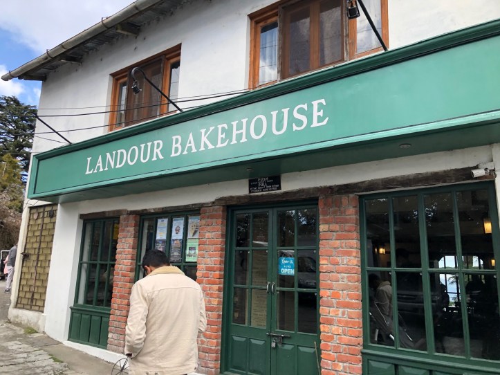
There’s a trail that goes right up to the Sister’s Bazaar from Jabarkhet. Infact this trail follows the boundary wall of the Woodstock school. The climb is of an easy grade. About 500 metres into the walk, you will find yourself walking on a proper concrete road that goes towards Woodstock school on one side and towards Sister’s Bazaar/Char Dukaan on the other. You get great views of the Kolti Village from here. Sister’s bazaar has a famous bakery shop called the ‘Landour Bakehouse’. It’s quite popular among the locals as well as tourists for its bakery products. It’s a small bakery but has a very vibrant atmosphere. I highly recommend stopping-by for a while.
The journey ends a little further at Char Dukaan. Though I went walking all the way to the Picture Palace Bus stand to board an Uttarakhand Roadways bus to Dehradun, you can also look / or call for a taxi at Char Dukaan (cost about 400-500 bucks for a full vehicle). In case you bring your own vehicle, I suggest parking the vehicle around Char Dukaan area only.
So, at the end, we got back to our starting-point (Char Dukaan) covering about 14 kms in total. With all the stops in-between, we can fairly complete this trail in about 6 hours.
What’s next for me – The trail to kolti through the pump house is yet to be done. So, my next hike in this area is surely going to be this one.
