It has been a while since I last scribbled a blog post. I am a bit dismayed by this dash of sluggishness that has crept in, despite witnessing the ever-changing landscape of the Mussoorie hills in this first spell of monsoon showers. The last few days have seen a complete overcast, the darker shade of grey completing engulfing the Doon valley. In the overlooking hills of Mussoorie and Dhanaulti, the hill slopes appear fresh and brimming in their green façade. The rising plumes of mist from the hollows add to the scene’s quiet magnificence.
Every morning, with an unflagging fascination, I try to capture this splendour, sifting through spaces and altitude to fathom what might have possibly changed, and then relish even the slightest shift I notice in its appearance. Perhaps, it dawned on me gradually – the desire to once again pen down a post, as I browsed through my several folders that quietly hold vivid images of these pristine mountains. No, I meant the snow-kissed Himalayan peaks. It’s time to share some of these images with my readers.
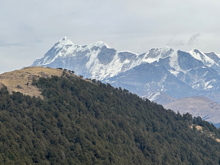
1. Kumaon Himalayan range | Kasar Devi – Almora (Kumaon)

Kasar Devi, nestled roughly 10 kms from Almora on the Bageshwar highway, offers stunning views of the Himalayan peaks. From here, you get a wide panoramic sweep of the range, with prominent peaks including Trishul, Mrigthuni, Devtoli, Maiktoli, Nanda Devi (I and II) and Panwali Dwar.
Location on Google Map – Click here (Kasar Devi)
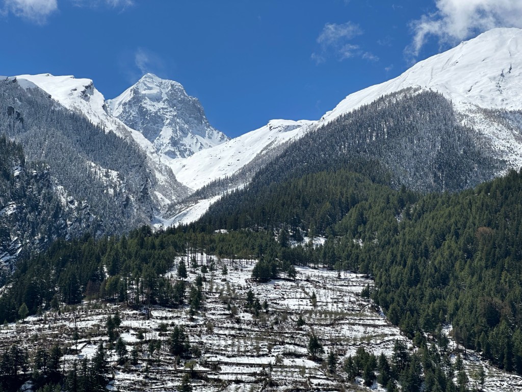
2. In the Shadow of Nanda Devi | India’s 2nd Highest Peak| Chhati Village – Bageshwar (Kumaon)
Nanda Devi twin-peaked massif (I & II) and Panwali Dwar (just in front) appear strikingly close and vivid, almost as if you could reach out and touch them. Nanda Devi I (7,816 metres), the main peak, is the second highest mountain in India (after Kangchenjunga). This picture was clicked from a roadside restaurant at Chhati village (near Mankot), roughly 12 kms ahead of Bageshwar on the Kanda-Berinag route.
Location on Google Map – click here (Chhati Village)
3. To the Source: Gaumukh | Holy Ganga’s Snout | Uttarkashi (Garhwal)

One of the most popular treks in Uttarakhand, the trail to Gaumukh – the snout of the Holy Ganga, can be reached after an easy to moderate trek of about 19 kms from the nearest roadhead at Gangotri, the sacred town and the summer abode of Goddess Ganga. The region offers numerous trekking options, ranging from easy to difficult grades.
Location on Google Map – Click Here (Gaumukh)
4. Bagori village | Let it remain a little secret | Uttarkashi (Garhwal)

Bagori is a tiny village located near Harsil town, roughly 25 kms from Gangotri. During the 1962 India-China war, inhabitants of the bordering villages of Nelong and Jadung were resettled here. The place carries a distinct vibe, the intricately designed wooden houses, the narrow alleys, the sound of the gushing waters from the Jalandhari and Bhagirathi rivers flowing not so far away, and the spiralling towers of the surrounding massif, all of it leaves you completely in awe.
Location on Google map – Click Here (Bagori Village)
Want to read up more on Harsil and Bagori village ? Here’s my dedicated post on them Harsil Valley – Click Here
5. Vijaypur’s tea estates |In the backdrop of Himalayas – Bageshwar (Kumaon)

Vijaypur is a tiny hamlet on the Bageshwar – Berinag route, known for its colonial-era tea estates, which are now witnessing a remarkable revival. The white, pristine Himalayan peaks form a perfect backdrop to the vast tea gardens that gently slopes down the mountainside.
Location on Google map – Click here -(Vijaypur town)
Interested to read up more about Vijaypur? Check out my post –Vijaypur Tea Garden
6. Where Trishul meets Trishul Peak | Divine sights enroute to Brahmatal – Chamoli (Garhwal)

Enroute to Brahmatal, a fascinating high-altitude trek in Chamoli, I paused at a rest stop called ‘Jhandi Top’, where I witnessed a striking alignment of Shiva’s Trishul and the mighty Trishul peak. This powerful amalgamation seemed to hold the strength to heal the world’s sufferings and radiate divine blessings far and wide.
Location on Google Map – Click here – Jhandi Top (Garhwal)
7. Mahasar Tal | Where Magnificence finds new meaning | Tehri (Garhwal)
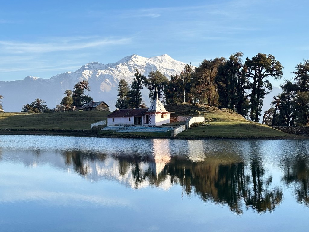
Tucked away in a remote corner of Tehri town, Mahasar Tal is pure bliss. Reached via a trek of about 8 kms from the nearest roadhead, this place is protected in nature’s arms, with towering cliffs keeping their watchful eyes over it.
Location on Google Map – Click here Mahasar Tal (Garhwal)
Documented my Mahasar Tal hike in a full post – take a look – Mahasar Tal Trek Tehri
8. The path to Heaven on earth | Panchachuli Base camp – Darma Valley | Pithoragarh (Kumaon)
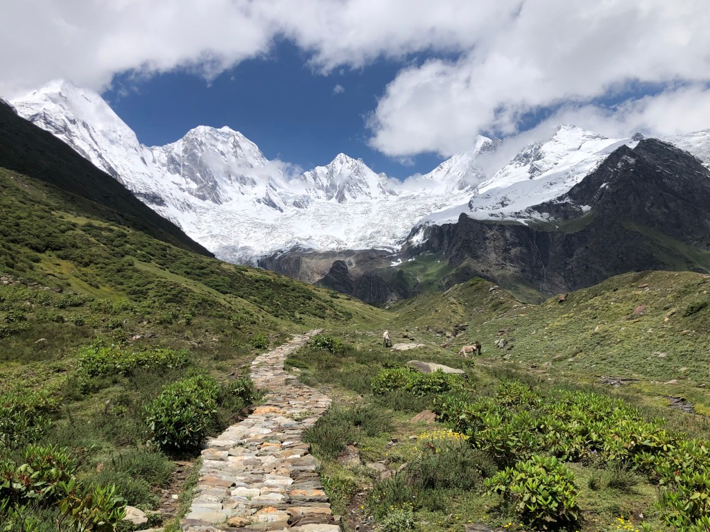
Darma valley is a remote region bordering Tibet, nestled in the Pithoragarh district of Uttarakhand. From the village of Dugtu, you can undertake an easy walk to the base of the majestic Panchachuli peaks. Aren’t we blown away by the grandeur and beauty of the peaks ? It is said that before ascending to heaven, the Pandava brothers cooked their last meal on these peaks, one for each brother.
Location on Google Map – Click Here Panchachuli Zero Point (Kumaon)
I have written several posts on Darma valley. Link for one such post – Darma Valley Pithoragarh
9. Chaukhamba | Four-Cornered Majesty | Rudraprayag (Garhwal)

This four-cornered sheer beauty can be easily spotted if you’re in Rudraprayag. Numerous treks and their summit points offer different perspectives of this peak. I hold several images of it – captured in different hues, seasons, and forms and yet, it continues to inspire me and hold my imagination every time I see it.
Location on Google map – Click Here seen from several places in the district (Garhwal).
Check out my dedicated post on Chaukhamba—featuring views from various spots –Chaukhamba-the-four-pillared-peak
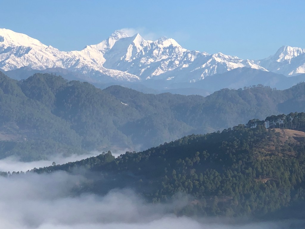
10. Blue sky, the Fog, the peaks | Morning view of Kumaon Himalayas from Bageshwar

The road from Bageshwar to Berinag , as it winds upward, reveals breathtaking vistas just a few kilometres into the drive. I especially admire this route in the winter months – while Bageshwar town remains shrouded in thick morning fog, just a little higher up, it’s a bright, sunny and pleasantly warm day. Against a spotless blue sky, the distinct white texture of the endless stretching Himalayas is truly unmissable.
Location on Google map – Click Here Mankot Village, Bageshwar (Kumaon)
11. Sri Kantha peak | The Silent Sentinel above Mukhba – Goddess Ganga’s Winter Abode | Uttarkashi – Garhwal
Sri Kantha Peak, rising above 6,100 metres, is nestled in the western Garhwal region of Uttarakhand. It stands on the opposite side of the Mukhba hill, overlooking the Upper Taknore Valley, through which the mighty Bhagirathi River flows.
Location on Google Map – Click Here Dharali (Garhwal)
An interesting story of Frederick Pahadi Wilson, who once lived here. Check out my dedicated post on Frederick Pahadi Wilson of Harsil
Enjoyed reading? Subscribe for updates on every new post.
We come to the end of this post, and I hope the pictures of these pristine peaks enthralled you. Perhaps you’ll soon find yourself on a journey to experience the beauty of one much Himalayan marvel.
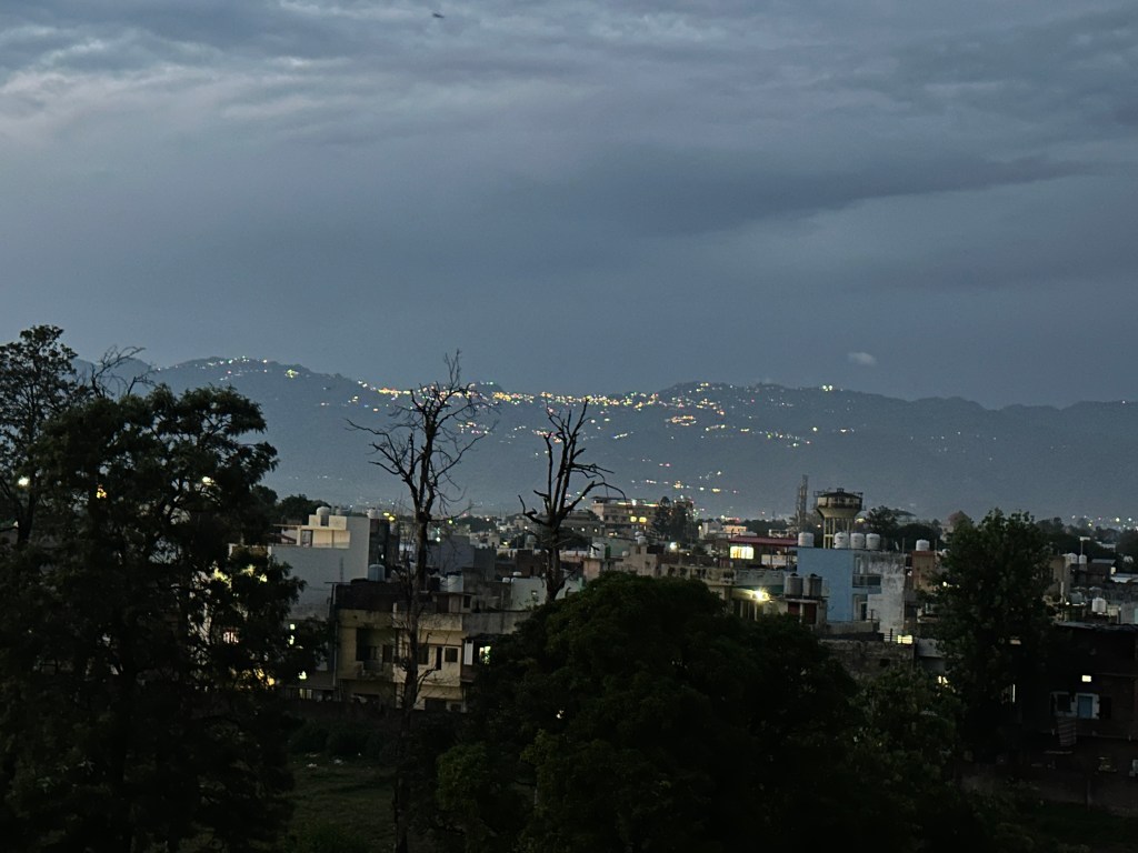
As I prepare to publish this post, the darkness of night gradually overpowers the fading sunlight. The sky remains overcast , yet I find myself smitten once again by the perfect purple silhouette of the mountains and the shimmering lights of the Mussoorie ridge, as I stand quietly on my balcony, absorbing it all.
